


zaouïa d'Ifrane

ahmed Ramzi
User
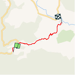

Length
2.3 km

Max alt
1429 m

Uphill gradient
5 m
Km-Effort
3 km

Min alt
1213 m

Downhill gradient
210 m
Boucle
No
Creation date :
2019-03-03 11:16:22.146
Updated on :
2019-03-03 12:24:45.825
40m
Difficulty : Easy

FREE GPS app for hiking
 SityTrail
IGN / Geographical institutes
SityTrail World
The world is yours!
About
Trail Trail of 2.3 km to be discovered at Fez-Meknes, cercle d'Azrou دائرة أزرو, Had Oued Ifrane. This trail is proposed by ahmed Ramzi.
Photos


Positioning
Country:
Morocco
Region :
Fez-Meknes
Department/Province :
cercle d'Azrou دائرة أزرو
Municipality :
Had Oued Ifrane
Location:
Unknown
Start:(Dec)
Start:(UTM)
273142 ; 3674849 (30S) N.
Comments
Trails nearby